Moon image from Ikarus:
- Ikarus Moon.jpg (52.45 KiB) Viewed 7120 times
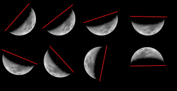
The 8 moons above, do I interpret as
Img 1: angle 40 degrees Latitud: N 50 degrees, Moon is in "growing phase", approx 8 days to full moon
Img 2: angle 50 degrees Latitud: N 40 degrees, Moon is in "growing phase", approx 8 days to full moon
Img 3: angle 60 degrees Latitud: N 30 degrees, Moon is in "growing phase", approx 8 days to full moon
Img 4: angle 90 degrees Latitud: N 0 degrees, Moon is in "growing phase", approx 8 days to full moon
Img 5: angle 120 degrees Latitud: S 30 degrees, Moon is in "growing phase", approx 8 days to full moon
Img 6: angle 140 degrees Latitud: S 50 degrees, Moon is in "growing phase", approx 8 days to full moon
Img 7: angle 20 degrees Latitud: N 70 degrees, Moon is in "shrinking phase", approx 8 days after full moon
Img 8: angle 90 degrees Latitud: N 0 degrees, Moon is in "shrinking phase", approx 8 days after full moon
What I mean is that the image of the moon always varies with latitude.
E.g. a moon like Img 5 or 6 can never be seen north of the equator
I am no expert, so please correct me if I'm wrong!

